As fall approaches, what better way to appreciate the colorful foliage by going on a hike? It's the perfect time to grab some friends, see some new sights and take in the crisp fall air.
Columbia residents can find hiking spots ranging from 20 minutes away to a few hours, each providing a different experience. Whether it's a walk in the park, climbing a mountain or gazing at waterfalls, here are some of the best local spots to help you get outside this fall!
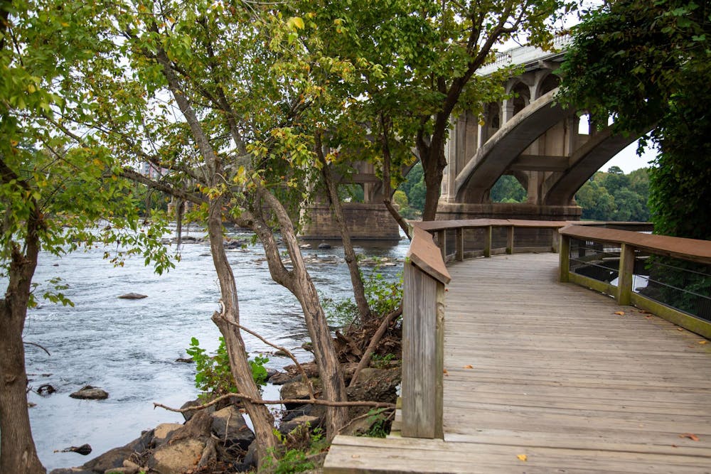
Located between Gervais Street and Knox Abbott Drive, the West Columbia Riverwalk is a seven-minute drive from campus and spans for eight miles. The riverwalk includes a system of boardwalks, bridges, overlooks and a lighted central path alongside the Congaree River. This hike is mainly flat, creating easy conditions to go on a scenic jog, bike ride or just a simple walk. If you are a student looking to get outside without having to make it a day trip, this is a great option.
Located at 9564 Two Notch Road, Sesquicentennial State Park — commonly known as "Sesqui" — provides a green getaway that's a mere 25-minute drive from campus. It includes 1,400 acres of pine trees, nature trails and camping sites. Sesqui consists of a large trail loop that has smaller trails scattered within it. The park offers fishing, canoe and kayak rentals, bird watching, a dog park and boat rentals.
The park provides recreational options for all ages and hosts yearly events such as a Full Moon Hike, Howl-O-Ween (a pet costume contest) and a Santa's at Sesqui 5k. The trails are mainly flat and span deep into the forest, providing the perfect opportunity to view the fall foliage.

Located in Richland County, Congaree National Park is a 27-minute drive from campus. According to The National Park Service, Congaree is the largest remaining old growth bottomland hardwood forest remaining in the southeastern United States. The Congaree River sweeps through this park, giving patrons the chance to walk on boardwalks through the swampy area. Congaree offers hikes of varying lengths through the back country, giving options for visitors of all abilities.
Along with hiking, the park offers opportunities to fish, camp and rent canoes. The combination of the Congaree river and the tall trees creates a well-rounded experience for any hiker.
Located at 158 E Ellison Lane, Table Rock State Park is a two-and-a-half hour drive from campus. Although it is one of the farther options, Table Rock offers mountainous views that Columbia's hikers can't find close by. The park offers multiple different trail options, including a hike up Table Rock Mountain, or an easy-going walk on its lakeside trail. Table Rock State Park offers fishing opportunities and camping spots, as well as a "Music on the Mountain" program, where local musicians gather to play bluegrass music in front of the scenic mountain view.
You can grab a few friends and make a day out of this road trip. It provides an opportunity to take a break from Columbia and see a majestic view of this seasons fall colors woven within the mountains.
Located at 3677 State Park Road, Dreher Island State Park is a 50-minute drive from campus. The park spans over three islands around Lake Murray. Dreher Island is 348 acres and provides 12 miles of path access to Lake Murray. Murray is also a popular fishing site, being home to some national fishing tournaments, such as the American Fishing Tour Championship. There is a bridge connecting two of the islands, giving patrons the opportunity to move from island to island while taking in the scenery.
Dreher Island gives students the opportunity to go to a lake front while getting in some hiking. Being less than an hour from campus, it makes for an easy day trip.
Located at 161 Holcombe Circle, Devils Fork State Park is a two-and-a-half hour drive from campus. Although a farther commute, Devils Fork offers a beautiful landscape view with a quiet lake settled into the mountain range. The park features hiking paths around the lake, giving patrons the opportunity to take in the views of different mountains and waterfalls. The 7,565-acre Lake Jocassee only has public access through Devils Fork, making for a clear, underdeveloped area. There are four mountain streams and several different waterfalls that feed into the lake.
Visiting Devils Fork gives students the opportunity to see a different area of South Carolina, and provides a chance to see a body of water surrounded by the mountainous fall foliage.
Whether you’re thinking of going on a road trip or a quick scenic run, South Carolina offers multiple different hiking opportunities to fit students needs at any skill level.